October 2005
Monthly Archive
Monthly Archive
Maurizio 03 Oct 2005 | : Events, Maps, NASA WorldWind, Satellite Imagery, Virtual Globes
In occasion of the World Space Week (4-10 October 2005) WorldWind South Africa was introduced in South African schools.

This electronic atlas of Southern Africa fruit of the collaboration of MadMappers, NASA, the SA Department of Science and Technology and coordinated by the SA Space Organization.
The launch in Pretoria, Durban and Cape Town was attended by Frank Frank Kuehnel (NASA Learning Technologies) who also gave a preview of of the Moon in 3D. In fact World Wind not only allows you to view the Earth in 3D, but also brings the universe to a desktop PC and is thus ideal in the creation of a “space culture”. In Frank’s own words the South African version simply showed how big the potential is for other people to step in and contribute! I think this opens a new paradigm of data distribution.
Mark Doherty from ESA ESRIN (the European Space Agency Centre for Earth Observation) was highly interested in MadMappers’ World Wind South Africa as a medium to bring ESA data to Africa. Mark extended an open invitation for MadMappers to present the project at ESA ESRIN headquarters in Frascati, Italy.
… will we ever be able to afford the trip? …
WorldWind is an open source 3D interactive world viewer created by NASA’s Learning Technologies project and released in mid-2004. It is now developed by NASA staff and open source community developers.
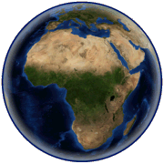
Essentialy WorldWind is a 3D “desk globe” which allows any user to zoom from outer space into any place on Earth. By simply using the mouse, the user is able to rotate the Earth or zoom closer to any point on the surface. WorldWind leverages satellite imagery and elevation data to allow users to experience Earth terrain in visually rich 3D, just as if they were really there, virtually visiting any place in the world. In actual fact WorldWind is truly an interplanetary tool capable of visualizing “other worlds” such as the Moon, Mars, Venus and Jupiter and then go on to explore the far reaches of the universe itself.
MadMappers’ aim is to offer African users an open source customable platform on which to display spatial information relative to their country. World Wind Africa servers will eventually supply a wide selection of data, ranging from topological maps to vector data, from aerial photography and very high resolution imagery to DEMs.
Special thanks to the Free Earth Fundation and the World Wind Community (in particular to Nowak, f0urtyfive and Bull_[UK]) for making this project possible.
NASA World Wind Version 1.3.5 (May 12, 2006)
(58,8 MB download)
 |  |  |  |  |  |  |  |
 |  | ||||||
| By N2H | |||||||